Topography
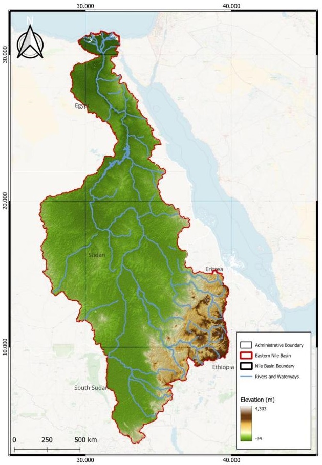
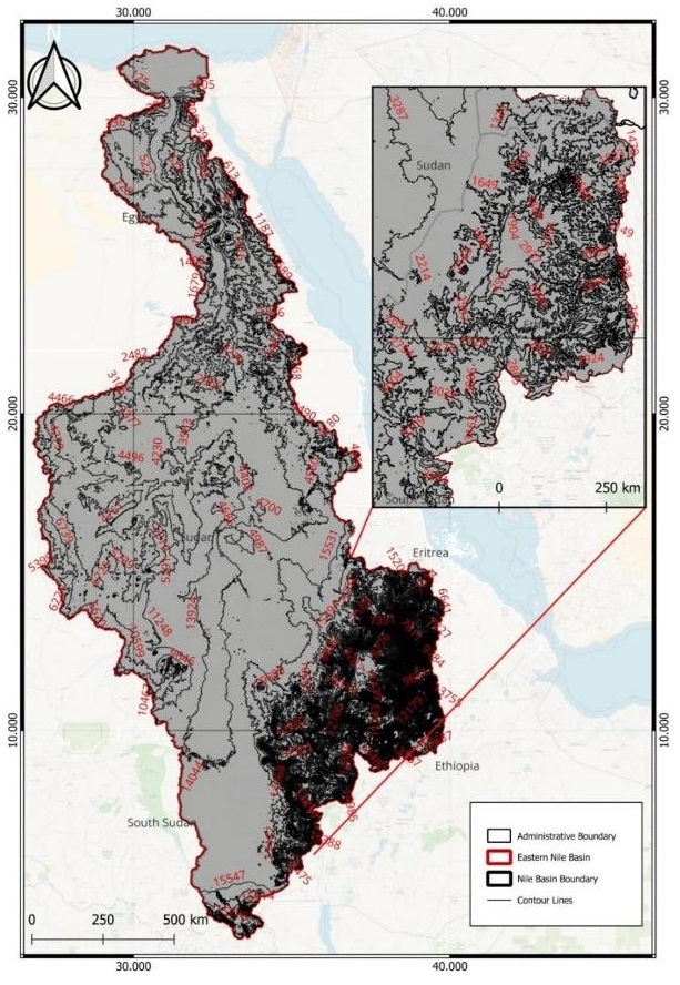
The Eastern Nile Basin (ENB) has a very varied landscape, with mountains, wetlands, waterfalls, and deserts. The highlands rise to an elevation of more than 4,000 meters, whereas most of the study area is below 1,500 meters above sea level. Most of these highlands are found on the eastern Ethiopian plateau, which is where Lake Tana is where the Blue Nile River rises (Nashwan & Shahid, 2019). There is a significant degree of steepness on the Ethiopian plateau when compared to the remnant area of the eastern Nile Basin.


Figure 1 : Digital Elevation Model (DEM) of the Eastern Nile Basin. Source ()
Figure 2 : Steeopness of the Eastern Nile Basin. Source ()
Soils
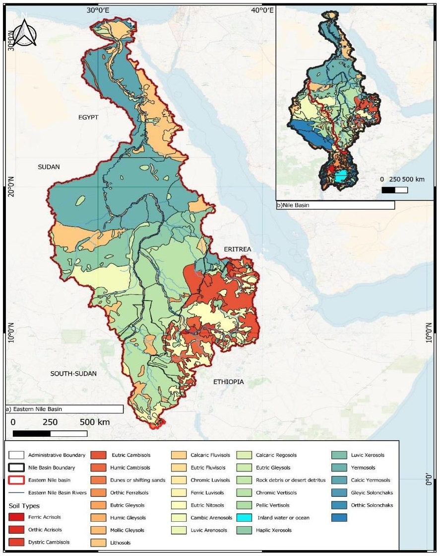
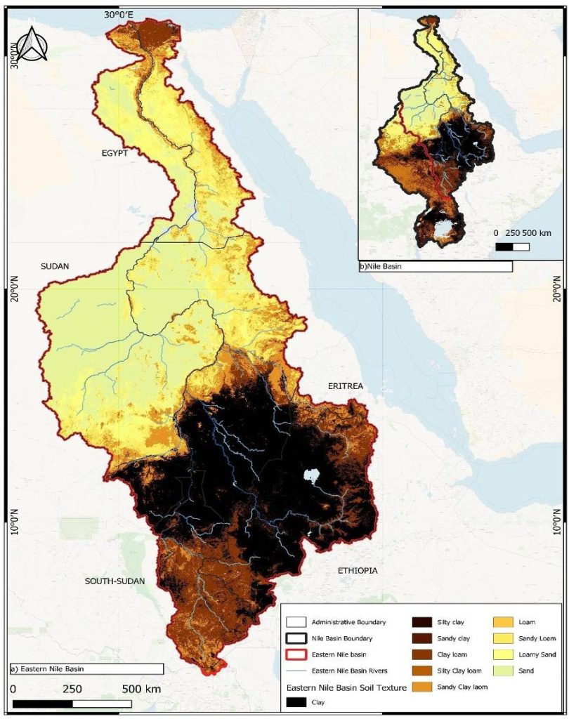
The Eastern Nile Basin spans over five countries and therefore, has a variety of soil types. Based on the soil distribution map and on the FAO classification system, the most fertile ones are Eutric Cambisols (mostly found in Ethiopia, Sudan, and South Sudan), Calcaric fluvisols (more dominant in Egypt and Sudan along the Nile Valley and the Nile delta), Eutric fluvisols (mostly found in Egypt and Sudan), Chromic fluvisols, Eutric nitosols and Pellic vertisols (FAO & UNESCO, 1974; IUSS Working Group WRB, 2022). This covers only 16.82% of the soils in the Eastern Nile Basin. Regarding the soil texture, Clay soils are prevalent in South Sudan and parts of Ethiopia. These soils are prone to compaction and waterlogging, while sandy soils that are rapidly drained hence, requiring frequent irrigation, are scattered throughout the region. Loam and clay-loam soils along the Nile River and Delta are ideal for intensive agriculture due to their balanced properties (Van Noordwijk, 1984).


Figure 3: Spatial distribution of soil types in the Eastern Nile Basin. Source ()
Figure 4: Spatial distibution of soil texture in the Eastern Nile Basin. Source ()
The Eastern Nile Basin (ENB) has diverse soil characteristics, Regarding Soil pH, 43.98% of the ENB is neutral, 38.90% is slightly acidic, 9.33% is alkaline, and 7.79% is very acidic. Sudan has a high percentage of very acidic soils (54.96%), while Egypt leads in alkaline soils (37.34%), and South Sudan predominantly has neutral soils (84%) (FAO & IIASA, 2023; Fischer et al., 2008). The type of clay minerals, such as kaolinite and smectite, affects soil cation exchange capacity (CEC), with smectite-rich soils in Sudan and South Sudan having higher CEC (El-Affendi, 2022; Fischer et al., 2008). Water availability is critical for soil organic carbon (SOC) and nutrient transportation, while soil pH influences nutrient solubility (Olness & Archer, 2005). Neutral soils offer better phosphorus availability, but acidic soils may release toxic aluminum (Mukherjee, 2022). In Egypt, reduced moisture and high evaporation can increase soil salinity, impacting agricultural productivity, especially if water from the GERD is mismanaged (Elbana et al., 2014; Fehlberg & Stahr, 1985). Flooded irrigation in Sudan helps with salt leaching, but lower water levels could worsen land degradation in arid regions downstream (El-Affendi, 2022).
References
- El-Affendi, A. (2022). Impact of Grand Renaissance Dam (GERD) on agriculture in the Sudanese Blue Nile Basin. https://infonile.org/en/2022/12/impact-of-grand-renaissance-dam-gerd-on-agriculture-in-the-sudanese-blue-nile-basin/
- Elbana, T., Bakr, N., Karajeh, F., & El Quosy, D. E. D. (2014). Treated Wastewater Utilization for Agricultural Irrigation in Egypt.
- FAO & IIASA. (2023). Harmonized World Soil Database version 2.0. https://doi.org/10.4060/cc3823en
- FAO & UNESCO. (1974). Soil map of the world. 1. Unesco.
- Fehlberg, H., & Stahr, K. (1985). Development of sustained land use by understanding soil and landscape formation in the desert fringe area of NW-Egypt. CATENA, 12(4), 307–328. https://doi.org/10.1016/0341-8162(85)90021-9
- Fischer, G., Nachtergaele, F., Prieler, S., van Velthuizen, H., T., Verelst, L., & Wiberg, D. (2008). Global Agro-ecological Zones Assessment for Agriculture (GAEZ 2008) [Raster database]. https://www.fao.org/soils-portal/data-hub/soil-maps-and-databases/harmonized-world-soil-database-v12/en/
- Hengl, T., Heuvelink, G. B. M., Kempen, B., Leenaars, J. G. B., Walsh, M. G., Shepherd, K. D., Sila, A., MacMillan, R. A., Mendes De Jesus, J., Tamene, L., & Tondoh, J. E. (2015). Mapping Soil Properties of Africa at 250 m Resolution: Random Forests Significantly Improve Current Predictions. PLOS ONE, 10(6), e0125814. https://doi.org/10.1371/journal.pone.0125814
- IUSS Working Group WRB. (2022). World Reference Base for Soil Resources. International soil classification system for naming soils and creating legends for soil maps. (4th edition). International Union of Soil Sciences (IUSS).
- Mukherjee, S. (2022). Current Topics in Soil Science: An Environmental Approach. Springer International Publishing. https://doi.org/10.1007/978-3-030-92669-4
- Nashwan, M. S., & Shahid, S. (2019). Spatial distribution of unidirectional trends in climate and weather extremes in Nile river basin. Theoretical and Applied Climatology, 137(1–2), 1181–1199. https://doi.org/10.1007/s00704-018-2664-5
- Olness, A., & Archer, D. (2005). EFFECT OF ORGANIC CARBON ON AVAILABLE WATER IN SOIL: Soil Science, 170(2), 90–101. https://doi.org/10.1097/00010694-200502000-00002
- Van Noordwijk, M. (1984). Ecology textbook for the Sudan. Ecology Textbook for the Sudan.